- Trust but verify: Validating new measures for mapping social infrastructure in cities (Urban Climate)
- Data tools for assessing disaster risk reduction: An analysis of open-access spatial disaster risk reduction datasets (2022 United Nations Global Assessment Report)
- Covid-19 to go? The role of disasters and evacuation in the Covid-19 pandemic (Global Environmental Change: Human and Policy Dimensions)
- Mapping resilience: GIS techniques for disaster studies (Research Methods of Disaster and Emergency Management: Approaches in Application)
- The role of social media in disaster recovery following Hurricane Harvey (Journal of Homeland Security and Emergency Management)
Trust but Verify:
Validating New Measures for Mapping Social Infrastructure in Cities
Abstract
Scholars and policymakers increasingly recognize the value of social capital - the connections that generate and enable trust among people - in responding to and recovering from shocks and disasters. However, some communities have more social infrastructure, that is, sites that produce and maintain social capital, than others. Community centers, libraries, public pools, and parks serve as locations where people can gather, interact, and build social ties. Much research on urban spaces relies on Google maps because of its ubiquity and this article tests the degree to which it can accurately, reliably, and effectively capture social infrastructure. In this study, we map the social infrastructure of Boston using Google Maps Places API and then ground truth our measures, mapping social infrastructure on street corners with in-person site observations to evaluate the accuracy of available data. We find that though we may need to use multi-vectored measurement when trying to capture social infrastructure, Google maps serve as reliable measurements with a predictable, acceptable margin of error.
Scholars and policymakers increasingly recognize the value of social capital - the connections that generate and enable trust among people - in responding to and recovering from shocks and disasters. However, some communities have more social infrastructure, that is, sites that produce and maintain social capital, than others. Community centers, libraries, public pools, and parks serve as locations where people can gather, interact, and build social ties. Much research on urban spaces relies on Google maps because of its ubiquity and this article tests the degree to which it can accurately, reliably, and effectively capture social infrastructure. In this study, we map the social infrastructure of Boston using Google Maps Places API and then ground truth our measures, mapping social infrastructure on street corners with in-person site observations to evaluate the accuracy of available data. We find that though we may need to use multi-vectored measurement when trying to capture social infrastructure, Google maps serve as reliable measurements with a predictable, acceptable margin of error.
Citation: Fraser, T., Cherdchaiyapong, N., Tekle, W., Thomas, E., Zayas, J., Page-Tan, C., and Aldrich, D.P. (2022) Trust but verify: Validating new measures for mapping social infrastructure in cities. Urban Climate. https://doi.org/10.1016/j.uclim.2022.101287

DATA TOOLS FOR ASSESSING DISASTER RISK REDUCTION:
AN ANALYSIS OF OPEN-ACCESS SPATIAL DISASTER RISK REDUCTION DATASETS
Abstract
This study explores the use of geospatial information, specifically open-access spatial data, and the implementation of the Sendai Framework for Disaster Risk Reduction 2015-2030, a framework designed to manage disaster risk. The priorities of the Sendai Framework are to (1) understand disaster risk; (2) strengthen disaster risk governance to manage risk; (3) invest in disaster risk reduction and resilience; and (4) enhance the capacity to recover from disasters. This study advances knowledge of implementing the Sendai Framework from publications that have utilized open-access spatial data and issues common to Framework implementation. This study also discusses how the issues could be addressed by those who have a vested interest in disaster risk reduction, from policymakers to community members.
This study reveals that the literature using open-access spatial data to study the implementation of the Sendai Framework cites real progress toward its goals. However, challenges remain, particularly issues in data quality and integrity; lack of resources and infrastructure; lack of political leadership or political corruption; and inconsistent standards with definitions and data collection. The findings from this review reveal that ensuring uniform standards; shared definitions; improved data quality; additional resources and infrastructure; and bottom-up approaches will be key to assessing implementation and progress toward the Sendai Framework.
Citation: Page-Tan, C. (2022) Data tools for assessing disaster risk reduction: An analysis of open-access spatial disaster risk reduction datasets. The 2022 UN Global Assessment Report on Disaster Risk Reduction (GAR). UN Office for Disaster Risk Reduction. https://www.undrr.org/publication/data-tools-assessing-disaster-risk-reduction-analysis-literature-using-open-access
COVID-19 TO GO?
THE ROLE OF DISASTERS AND EVACUATION IN THE COVID-19 PANDEMIC
Abstract
Since the start of the pandemic, some U.S. communities have faced record storms, fires, and floods. Communities have confronted the increased challenge of curbing the spread of COVID-19 amid evacuation orders and short-term displacement that result from hazards. This raises the question of whether disasters, evacuations, and displacements have resulted in above-average infection rates during the COVID-19 pandemic. This study investigates the relationship between disaster intensity, sheltering-in-place, evacuation-related mobility, and contagion following Hurricane Zeta in Southeastern Louisiana and The Wildfires in Napa and Sonoma Counties, California, known as the Glass Fire. We draw on data from the county subdivision level and mapped and aggregated tallies of Facebook user movement from the Facebook Data for Good program’s GeoInsights Portal. We test the effects of disasters, evacuation, and shelter-in-place behaviors on COVID-19 spread using panel data models, matched panel models, and synthetic control experiments. Our findings suggest associations between disaster intensity and higher rates of COVID-19 cases. We also find that while sheltering-in-place led to decreases in the spread of COVID-19, evacuation-related mobility did not result in our hypothesized surge of cases immediately after the disasters. The findings from this study aim to inform policymakers and scholars about how to better respond to disasters during multi-crisis events, such as offering hotel accommodations to evacuees instead of mass shelters and updating intake and accommodation procedures at shelters, such as administration temperature screenings, offering hand sanitizing stations, and providing isolated areas for ill evacuees.
Since the start of the pandemic, some U.S. communities have faced record storms, fires, and floods. Communities have confronted the increased challenge of curbing the spread of COVID-19 amid evacuation orders and short-term displacement that result from hazards. This raises the question of whether disasters, evacuations, and displacements have resulted in above-average infection rates during the COVID-19 pandemic. This study investigates the relationship between disaster intensity, sheltering-in-place, evacuation-related mobility, and contagion following Hurricane Zeta in Southeastern Louisiana and The Wildfires in Napa and Sonoma Counties, California, known as the Glass Fire. We draw on data from the county subdivision level and mapped and aggregated tallies of Facebook user movement from the Facebook Data for Good program’s GeoInsights Portal. We test the effects of disasters, evacuation, and shelter-in-place behaviors on COVID-19 spread using panel data models, matched panel models, and synthetic control experiments. Our findings suggest associations between disaster intensity and higher rates of COVID-19 cases. We also find that while sheltering-in-place led to decreases in the spread of COVID-19, evacuation-related mobility did not result in our hypothesized surge of cases immediately after the disasters. The findings from this study aim to inform policymakers and scholars about how to better respond to disasters during multi-crisis events, such as offering hotel accommodations to evacuees instead of mass shelters and updating intake and accommodation procedures at shelters, such as administration temperature screenings, offering hand sanitizing stations, and providing isolated areas for ill evacuees.
Citation: Page-Tan, C. and Fraser, T. (2022) Covid-19 to go? The role of disasters and evacuation in the Covid-19 pandemic. Global Environmental Change: Human and Policy Dimensions. https://doi.org/10.1016/j.gloenvcha.2022.102471
Mapping resilience:
GIS techniques for disaster studies
Abstract
This chapter provides an overview of the geographic information systems (GIS) methods and techniques commonly employed by researchers of natural hazards. In doing so, each section will provide a brief overview and summary of the tools discussed, common questions that can be addressed by the tools, and examples from researchers who have applied those tools in actual cases of hazards and disasters. This chapter is by no means an exhaustive overview of all the tools at our disposal. Instead, this chapter provides an initial overview of the commonly used spatial tools to familiarize students and researchers on how GIS tools and techniques can be applied to studying natural hazards.
This chapter provides an overview of the geographic information systems (GIS) methods and techniques commonly employed by researchers of natural hazards. In doing so, each section will provide a brief overview and summary of the tools discussed, common questions that can be addressed by the tools, and examples from researchers who have applied those tools in actual cases of hazards and disasters. This chapter is by no means an exhaustive overview of all the tools at our disposal. Instead, this chapter provides an initial overview of the commonly used spatial tools to familiarize students and researchers on how GIS tools and techniques can be applied to studying natural hazards.
Citation: Page-Tan, C., Fraser, T. and Aldrich, D.P. (2021) Mapping resilience: GIS techniques for disaster studies in Jason D. Rivera, ed., Research Methods of Disaster and Emergency Management: Approaches in Application. Routledge. https://doi.org/10.4324/9780367823948-22
THE ROLE OF SOCIAL MEDIA IN DISASTER RECOVERY FOLLOWING HURRICANE HARVEY
Abstract
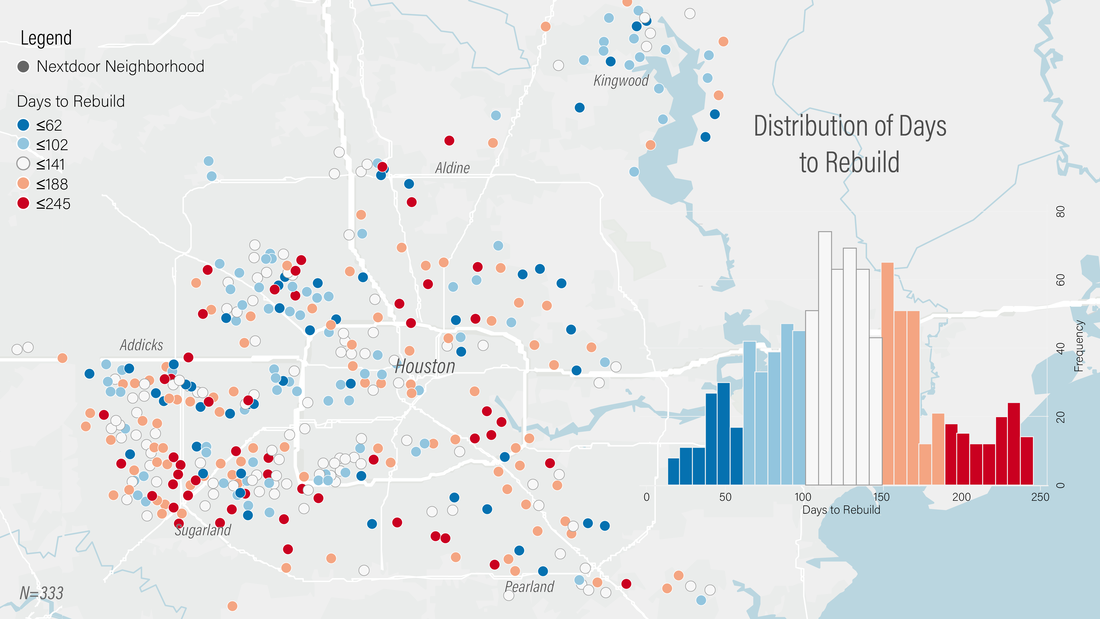
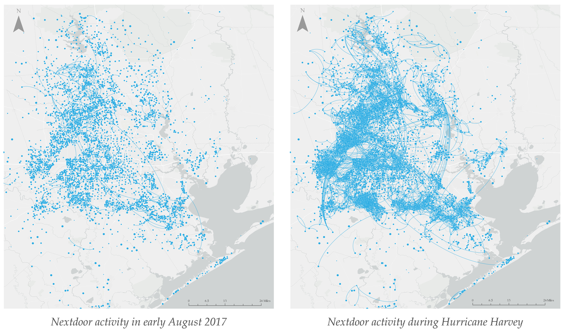
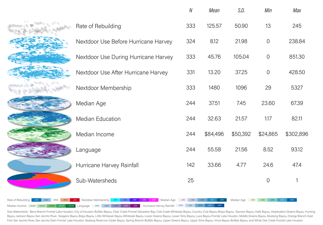
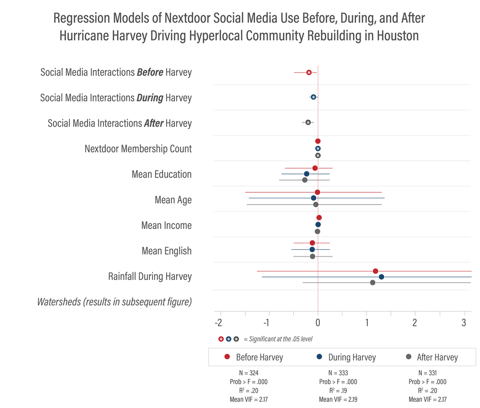
Hurricane Harvey was social media's first real stress test as a disaster response and recovery mechanism. A confluence of conditions makes it an ideal case study of social media's role in disaster recovery: the lack of a government-issued evacuation order, a call from government leadership for willing and able volunteers with a boat or high-water vehicle to perform life-saving rescues, and wide-spread adoption of social media platforms in the Houston area. While research on online social networks and disasters continues to grow, social scientists know little about how these online networks transform during a crisis and, further, how they drive disaster outcomes. With two original datasets, this study investigates how Houston's online social network transformed during Hurricane Harvey (2017), and the relationship between social media activity and post-Harvey recovery. The findings of a social network analysis (N= 2,387,610) and subsequent statistical analyses reveal the Houston-area online social network grew denser, clustered, and more efficient during the disaster. A spatial analysis and three separate regression models of activity before, during, and after Hurricane Harvey reveal that among 333 Nextdoor Neighborhoods, hyperlocal social media activity was a statistically significant predictor of the rate of rebuilding in these geographically based online communities. These findings suggest that policy and decision-makers should invest into online and offline hyperlocal social networks well before a disaster strikes, and leverage resources and legislation to maintain and strengthen the telecommunications and energy infrastructure that supports access to social media and telecommunications infrastructure during a time of crisis.
Hurricane Harvey was social media's first real stress test as a disaster response and recovery mechanism. A confluence of conditions makes it an ideal case study of social media's role in disaster recovery: the lack of a government-issued evacuation order, a call from government leadership for willing and able volunteers with a boat or high-water vehicle to perform life-saving rescues, and wide-spread adoption of social media platforms in the Houston area. While research on online social networks and disasters continues to grow, social scientists know little about how these online networks transform during a crisis and, further, how they drive disaster outcomes. With two original datasets, this study investigates how Houston's online social network transformed during Hurricane Harvey (2017), and the relationship between social media activity and post-Harvey recovery. The findings of a social network analysis (N= 2,387,610) and subsequent statistical analyses reveal the Houston-area online social network grew denser, clustered, and more efficient during the disaster. A spatial analysis and three separate regression models of activity before, during, and after Hurricane Harvey reveal that among 333 Nextdoor Neighborhoods, hyperlocal social media activity was a statistically significant predictor of the rate of rebuilding in these geographically based online communities. These findings suggest that policy and decision-makers should invest into online and offline hyperlocal social networks well before a disaster strikes, and leverage resources and legislation to maintain and strengthen the telecommunications and energy infrastructure that supports access to social media and telecommunications infrastructure during a time of crisis.

Citation: Page-Tan, C. (2020). The role of social media in disaster recovery following Hurricane Harvey. Journal of Homeland Security and Emergency Management, 18(1), 93-123. https://doi.org/10.1515/jhsem-2018-0054